Introduction: Turning Concern into Confidence
Living in Florida comes with incredible rewards, from sunny beaches to vibrant communities. It also means sharing our home with a powerful force of nature: tropical storms and hurricanes. If you feel a knot in your stomach when a new storm appears on the map, you’re not alone. That feeling is a sign of respect for the power of these systems. But we believe that respect should be paired with confidence, not fear. This guide is designed to be your friendly, supportive companion. We’ll walk through everything you need to know about tropical storms in Florida, from the science behind them to the practical steps you can take to keep your family safe. Our goal is to transform anxiety into action, ensuring you feel prepared, informed, and resilient.
Why Florida? Understanding Our Unique Vulnerability
Florida’s beautiful geography is also what makes it so susceptible to tropical weather. Imagine our state as a vast peninsula, a piece of land almost entirely surrounded by water. To the east is the warm Atlantic Ocean, and to the west is the even warmer Gulf of Mexico. These bodies of water, often exceeding 80°F (27°C), act like a giant battery, charging up storms with immense energy. No matter which direction a storm comes from, Florida is often in its path. This is why our state leads the nation in hurricane and tropical storm landfalls. Understanding this reality isn’t about scaring you—it’s about acknowledging why preparedness is such a vital part of the Florida lifestyle.
The Power and the Pattern
Every year, as the ocean waters warm, we enter a season that commands our respect: hurricane season. The news begins to fill with terms like “tropical depression,” “tropical storm,” and various hurricane categories. It can feel overwhelming and even frightening. But here’s the most important thing to remember: knowledge is your greatest tool for safety and peace of mind. Understanding these storms demystifies them, transforming fear into preparedness.
This guide is designed to walk you through the life cycle of these powerful weather systems, collectively known as tropical cyclones, in a clear, caring, and supportive way. We will break down each stage, from the initial ripple in the atmosphere to the formidable hurricane. Our goal is not to alarm you, but to empower you with information. By the end of this article, you will confidently understand the differences between each stage and the appropriate steps to take for your safety and the safety of your loved ones. The central theme we will explore is the progression from a tropical depression to a hurricane, a journey fueled by specific atmospheric conditions.
The Starting Point: What is a Tropical Depression?
The journey of a major storm often begins humbly. The first sign of organization is a tropical depression. Think of this as the foundation upon which a larger storm can potentially build. It’s a cluster of thunderstorms that has developed a defined, closed circulation at the surface—meaning the winds have started to spin around a common center.
)")
The key identifier of a tropical depression is its wind speed. To be classified as such, the system must have maximum sustained winds of 38 miles per hour (61 km/h) or less. While this may sound mild compared to a hurricane, it’s crucial to understand that even at this earliest stage, a tropical depression can be dangerous. Its primary threat is not wind, but water. These systems can dump massive amounts of rain over a single area for an extended period, leading to significant flash flooding and river flooding, even far inland. This highlights a critical lesson in storm safety: never focus solely on the wind category. The water hazards associated with a system, from its initial formation as a tropical depression to its peak as a major hurricane, are often the greatest threat to life and property.
Alert System: In the U.S., the primary alert system for tropical depressions is managed by the National Oceanic and Atmospheric Administration (NOAA), mainly through the National Hurricane Center (NHC). While formal “watches” and “warnings” are reserved for tropical storms and hurricanes, the NHC issues regular advisories and outlooks to track and inform the public about tropical depressions.
Alerting products for tropical depressions
- Tropical Weather Outlook (TWO): This product assesses the potential for tropical cyclone formation over the next five days. It provides a color-coded probability forecast for areas of disturbed weather, allowing for early preparation even before a depression forms.
- Tropical Cyclone Advisory: Once a system is classified as a tropical depression, the NHC issues advisories at least every six hours. These text-based updates include information on the storm’s location, wind speed, pressure, and forecast track. When a coastal watch or warning is issued for a stronger system, advisories may increase to every three hours.
- Cone of Uncertainty: This graphic, issued with advisories, illustrates the probable path of the storm’s center. For a tropical depression, it is important to remember that impacts can extend far beyond the cone.
- Wireless Emergency Alerts (WEA): The National Weather Service (NWS) uses the WEA system to send high-priority alerts to mobile devices in affected areas. While most commonly used for stronger storms and severe weather events like tornado warnings, these alerts can be used to notify the public of significant threats from tropical systems.
How to receive alerts
- NOAA Weather Radio: This national network broadcasts official NWS warnings, watches, and forecasts around the clock, including updates on tropical systems.
- Smartphones and Mobile Devices:
- Wireless Emergency Alerts (WEA): Most modern smartphones are equipped to receive these free, government-authorized messages automatically based on your location. Check your phone’s notification settings to ensure they are enabled.
- Emergency Apps: The FEMA mobile app and many local news and weather apps (like the Fox Carolina First Alert Weather app For Android, For Apple) offer free notifications for severe weather.
- Online Resources: You can monitor the official progress of tropical depressions on the National Hurricane Center (NHC) website at
hurricanes.gov. For forecasts specific to your area, visit your local NWS office website atweather.gov. - Social Media: The NHC provides automatic updates when a new tropical advisory is issued via its Twitter accounts (@NHC_Atlantic and @NHC_Pacific).
Threat levels associated with tropical depressions
Even though tropical depressions have the lowest wind speeds of any tropical cyclone, they still pose significant risks.
- Flooding from Rainfall: Slow-moving tropical depressions can produce heavy rain for days, causing catastrophic freshwater flooding hundreds of miles inland.
- Tornadoes: Tropical systems can spawn tornadoes, particularly in the outer rain bands.
- Wind and Storm Surge: Though less severe than hurricanes, tropical depressions can still cause coastal flooding from storm surge and produce damaging winds.
Gaining Strength: The Tropical Storm Stage
When a tropical depression gathers more energy from the warm ocean waters, it can intensify into a tropical storm. This happens when its maximum sustained winds climb into the range of 39 to 73 miles per hour (63 to 118 km/h). This is a significant milestone because, at this point, the storm is given an official name from a predetermined list by meteorological organizations.
The naming system helps avoid confusion when multiple storms are active simultaneously and makes communication and warnings clearer for the public. As a tropical storm becomes more organized, it develops a more classic “pinwheel” shape that can often be seen from satellite imagery. The dangers present in the tropical depression stage are amplified. Rainfall becomes even heavier, and the increasing winds can start to cause damage—knocking down tree limbs, causing power outages, and generating dangerous surf and rip currents along the coast. This is the time when it is essential to begin actively monitoring the storm’s progress and reviewing your family’s emergency plan. The progression from a tropical depression to a hurricane is not inevitable, but the tropical storm stage indicates the system has found a favorable environment and is strengthening.
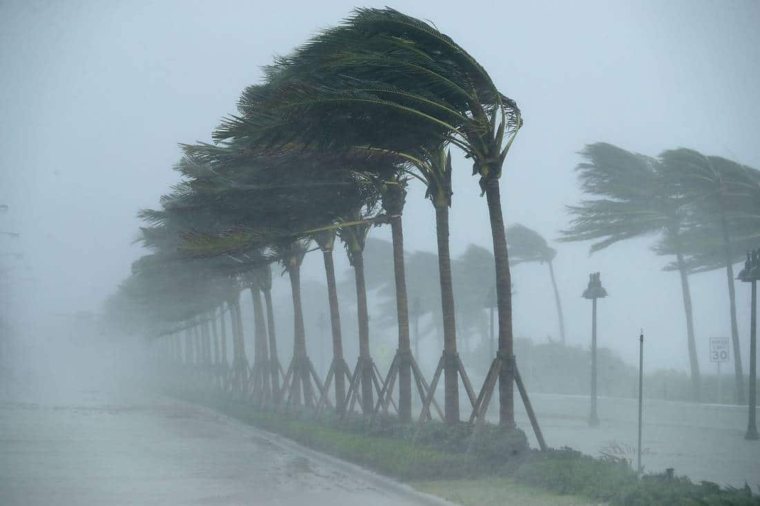
The Mature System: Anatomy of a Hurricane

If a tropical storm continues to move over warm water and is not disrupted by other atmospheric factors, it can intensify into the most powerful stage: a hurricane. A hurricane is defined by maximum sustained winds of 74 miles per hour (119 km/h) or greater. It’s important to know that the same type of storm is called a “typhoon” in the Northwest Pacific and a “cyclone” in the Indian Ocean and South Pacific.
A mature hurricane has a very distinct structure:
- The Eye: This is the calm, often clear center of the storm. The air is sinking here, leading to light winds and relatively fair weather. However, the eye is temporary and is surrounded by the storm’s most violent part.
- The Eyewall: This is a dense ring of clouds and intense thunderstorms that encircles the eye. The eyewall contains the hurricane’s strongest winds and heaviest rainfall.
- Rain Bands: These are long, curved bands of clouds and thunderstorms that spiral outward from the eyewall. They can extend for hundreds of miles and produce heavy rain and gusty winds.
Hurricanes are categorized from 1 to 5 on the Saffir-Simpson Hurricane Wind Scale, which is based solely on maximum sustained wind speed. This scale helps estimate potential property damage. However, it is a common and dangerous mistake to underestimate a Category 1 or 2 hurricane. Even these “lesser” hurricanes can produce catastrophic flooding and life-threatening storm surge. The complete journey from a tropical depression to a hurricane results in a complex and powerful engine of heat and wind.
More Than Just Wind: The Real Dangers of Hurricanes
While the wind speeds define the categories, the greatest threats from a hurricane often come from water. Understanding these hazards is a critical part of staying safe.
- Storm Surge: This is often the most significant threat to life during a hurricane. It is an abnormal rise of water generated by a storm’s winds, pushing ocean water toward the shore. This can cause devastating coastal flooding, with water levels rising several feet, sweeping away buildings and inundating roads.
- Inland Flooding: Hurricanes and tropical storms can unleash torrential rainfall, measured in feet, not inches. This rain can fall hundreds of miles inland, causing rivers and streams to overflow their banks. Many hurricane-related fatalities occur due to people driving or walking into floodwaters.
- Rip Currents and High Surf: Even storms far offshore can generate powerful and dangerous waves and rip currents along vast stretches of coastline, creating hazards for swimmers.
- Tornadoes: Hurricanes can also spawn tornadoes, which add another layer of danger, particularly in the right-front quadrant of the storm as it moves ashore.
Learning from the Past: A Look at Florida’s Storm History
We can learn valuable lessons from the storms that have shaped our state. While major hurricanes like Andrew (1992), Michael (2018), and Ian (2022) understandably grab headlines, it’s crucial to respect the power of tropical storms. For example, Tropical Storm Fay in 2008 dropped massive amounts of rain across the state, causing significant inland flooding. These events teach us that water is often the most dangerous part of any storm. By looking back, we can better prepare for the future, understanding that every system, regardless of its category, requires our attention.
Between 2015 and 2024, Florida was struck by numerous tropical storms and hurricanes, including several with a major impact. The most damaging storms during this decade were Hurricane Ian (2022), Hurricane Michael (2018), and Hurricane Irma (2017). The 2024 hurricane season was also particularly active, with multiple landfalls including major hurricanes Helene and Milton.
2024
- Hurricane Helene: Made landfall as a Category 4 storm on September 26 on the Big Bend coast near Perry. It brought destructive 140 mph winds and record storm surge of up to 15 feet. It is considered one of the costliest and deadliest U.S. storms since Hurricane Katrina in 2005.
- Hurricane Milton: A powerful and fast-intensifying Category 5 hurricane that hit Florida in October, shortly after Helene. Its rapid succession after Helene created an unprecedented challenge for the state and was the ninth hurricane of the 2024 Atlantic season.
- Hurricane Debby: As a Category 1 hurricane in August, Debby brought damaging winds and major flooding to the northern Gulf Coast.
- Hurricane Beryl: While Beryl weakened before it hit the U.S., it was a historically early Category 5 storm in July and was among the three Florida landfalls during the 2024 season.
2022
- Hurricane Ian: This devastating tropical cyclone made landfall in Southwest Florida as a high-end Category 4 storm. With sustained winds of 150 mph, it was the strongest to hit the area since Hurricane Charley in 2004.
- Impact: Ian was the costliest hurricane in Florida’s history, causing an estimated $112 billion in damage from flooding and storm surge. Millions lost power, and entire communities like Fort Myers Beach and Sanibel Island were leveled.
2019
- Tropical Storm Nestor: Affected Florida in October.
2018
- Hurricane Michael: Made landfall on October 10 as a Category 5 hurricane, with sustained winds of 161 mph, in the Florida Panhandle. It was the most powerful hurricane to strike the state since Andrew in 1992.
- Impact: Michael caused catastrophic damage from wind and storm surge across the Panhandle.
- Tropical Storm Gordon: Impacted the state in September.
- Tropical Storm Alberto: Affected Florida in May.
2017
- Hurricane Irma: Impacted the Florida Keys on September 10 after weakening from a Category 4 storm to a Category 3. Though the storm weakened, its sheer size brought widespread, destructive winds and storm surge across much of the state.
- Tropical Storm Cindy: Brought rain and wind to Florida in June.
2016
- Hurricane Matthew: Though it did not make a direct landfall, it paralleled Florida’s east coast, causing widespread wind and flood damage, particularly along the coast.
- Hurricane Hermine: Made landfall as a Category 1 hurricane in the Big Bend region, becoming the first hurricane to hit Florida since Wilma in 2005.
2015
- No significant hurricanes made landfall in Florida during the 2015 season.
Your Forecasting Toolkit: Trusted Sources for Tracking
In the age of information, it’s essential to know where to look for accurate, timely updates. Relying on official sources prevents the spread of misinformation and helps you make calm, informed decisions.
- National Hurricane Center (NHC): This is your absolute primary source for forecast tracks, intensity, and official watches/warnings. They are the experts.
- National Weather Service (NWS) Local Offices: For hyper-local impacts specific to your county, your local NWS office is invaluable.
- Reliable Media Outlets: Trusted local news meteorologists do an excellent job of interpreting the NHC data for our specific communities. Refer – Hurricane and Tropical Storm Watches, Warnings, Advisories and Outlooks
When you see “spaghetti models,” remember these are just individual computer forecasts. The NHC’s official forecast cone is a consensus of the best available data.
Your Official Support Network: Florida’s Emergency Management System
You have a whole team of experts working behind the scenes to keep you safe. Knowing these resources can make a world of difference.
- Florida Division of Emergency Management (FDEM): Your one-stop-shop for everything disaster-related is FloridaDisaster.org. This agency coordinates the state’s response and recovery.
- They manage the State Emergency Operations Center.
- They provide public updates and manage emergency alerts.
- They coordinate the distribution of essential supplies like water and food.
- Hurricane Loss Mitigation Program (HLMP): Did you know the state offers help to make your home stronger? The FDEM’s Hurricane Loss Mitigation Program provides funding for retrofitting and strengthening homes to better withstand hurricane-force winds. This is a proactive step toward long-term safety.
- Florida Health Department: Public health is a major concern during disasters. The Florida Department of Health ensures medical support in shelters, monitors for disease, and provides critical information on water safety and mental health resources.
- Florida Hospital Association (FHA): Hospitals are on the front lines during a disaster. The FHA’s Emergency Management program works to ensure our healthcare systems can continue to operate and provide care during and after a storm. They coordinate between hospitals to manage patient needs and resources.
- Florida Sea Grant: This program, a partnership between universities and the National Oceanic and Atmospheric Administration (NOAA), is a treasure trove of science-based information. They provide fantastic resources for coastal residents on topics like flood mitigation and disaster recovery, helping communities build back smarter.
- Federal Resources (USA.gov): This portal connects you to FEMA and other federal agencies that provide disaster assistance after a major declared disaster.
Building Resilience: How Florida is Preparing for the Future
Resilience is about bouncing back stronger. Florida is continuously learning and adapting to better withstand future storms. This involves a combination of community action, innovative science, and smart policy.
- Investing in Science: Universities like the University of Central Florida (UCF) have extensive hurricane preparedness programs, researching everything from building engineering to public policy to enhance community resilience.
- Innovative Construction: From updating building codes to exploring new designs like storm-resistant domed homes that have successfully weathered powerful hurricanes, Florida is embracing innovation to protect properties.
- Natural Defenses: There’s a growing emphasis on protecting and restoring natural barriers like mangroves and wetlands, which act as a buffer against storm surge.
- The Staggering Cost of Storms: According to data from the National Centers for Environmental Information (NCEI), Florida has sustained over $300 billion in damages from weather and climate disasters since 1980. This underscores the critical importance of investing in preparedness and mitigation now, to save lives and resources later.
Your Family’s Action Plan: A Step-by-Step Preparedness Guide
Let’s turn knowledge into action. Here is a simple, step-by-step plan you can start today.
Long Before the Season (Do This Now!):
- Know Your Zone: Visit FloridaDisaster.org and know if you live in an evacuation zone. This is the most critical first step.
- Build Your Kit: Assemble a “go-kit” for evacuation and a “stay-at-home” kit with at least 7 days of supplies for everyone in your household, including pets.
- Water (one gallon per person per day)
- Non-perishable food
- Battery-powered radio and flashlights
- First-aid kit and medications
- Important documents in a waterproof bag
- Cash and chargers
- Plan Your Communication: Decide how you will contact each other if separated. Identify a safe room in your home and an out-of-state contact person.
- Prepare Your Home: Trim trees, clear gutters, and decide how you will protect your windows. Look into the Hurricane Loss Mitigation Program for strengthening your home.
When a Storm is Forecast:
- Stay Informed: Monitor the NHC and FloridaDisaster.org closely.
- Follow Evacuation Orders: If told to evacuate, do not hesitate. As advised in the state’s official hurricane brochure, try to evacuate to the home of a friend or relative who lives in a safe, non-evacuation zone. Public shelters provide safety but not always comfort and may have restrictions on pets.
- Finalize Preparations: Secure your home, charge devices, and fill your gas tank.
During the Storm: Staying Safe Minute-by-Minute
- Stay Inside: Remain in your safe room, away from windows and glass doors.
- Use Your Radio: Listen for updates on your battery-powered NOAA weather radio.
- Beware of the Eye: If the wind stops, you may be in the eye of the storm. Stay inside; the winds will return violently from the opposite direction.
After the Storm: Navigating Recovery with Care
The danger doesn’t end when the rain stops.
- Wait for the All-Clear: Do not go outside until authorities say it is safe.
- Avoid Hazards: Stay away from flooded areas and downed power lines.
- Check on Neighbors: Once it’s safe, check on those around you, especially the elderly or those with special needs.
- Document Damage: Take photos for insurance claims before cleaning up.
- Prioritize Mental Health: Recovery is stressful. It’s okay to ask for help and lean on your community.
Conclusion: Empowerment Through Community and Preparation
Facing tropical storms in Florida is a reality, but it’s one we can meet with strength and solidarity. Remember, you are part of a community that includes your family, your neighbors, and a network of dedicated professionals working to keep us all safe. By taking proactive steps, staying informed through trusted sources, and looking out for one another, we build a resilience that no storm can break. Let’s carry the spirit of preparedness with us not as a burden, but as a promise—a promise to protect the people and the way of life that make Florida so special.
Visit https://inworldnews.com/ for more.
Feature Image: theglobeandmail.com