Live Humberto (2025) Tracking @ Zoom Earth !
NATIONAL HURRICANE CENTER and
CENTRAL PACIFIC HURRICANE CENTER
Understanding the Situation: The Birth of Tropical Storm Humberto
Hello and welcome. As we navigate the 2025 hurricane season, our focus turns to the Atlantic Ocean, where a new system has developed. Tropical Storm Humberto formed on September 24, 2025, marking the eighth named storm of the season. It’s completely understandable to feel a sense of concern when a new storm appears on the map. Our goal here is to provide you with clear, accurate, and supportive information to help you feel informed and prepared, not anxious.
This article will serve as your comprehensive guide to understanding Tropical Storm Humberto’s forecast, the science behind its tracking, and the practical steps you can take to ensure your safety and peace of mind. We’ll lean on authoritative sources like the National Hurricane Center (NHC) and NOAA to ensure everything we share is reliable. Remember, knowledge is the first step toward preparedness.
The Official Forecast: What the Experts at the National Hurricane Center Say
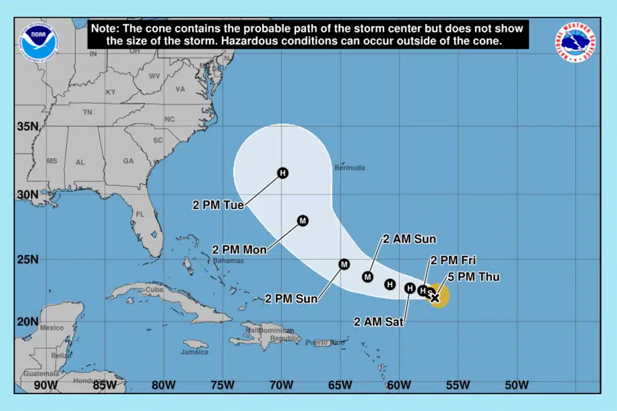
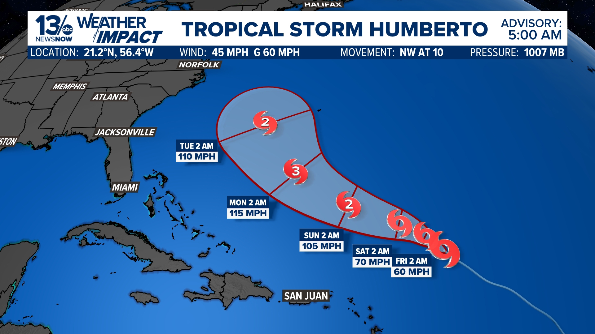
The National Hurricane Center (NHC), a division of the National Oceanic and Atmospheric Administration (NOAA), is our most trusted source for storm information. Their team of expert meteorologists is working around the clock to analyze data and provide forecasts. According to the latest NHC advisories, Tropical Storm Humberto is currently located in the central Atlantic, east of the Leeward Islands.
The key points from the official tropical storm humberto forecast indicate that the storm is undergoing steady to rapid strengthening. It is expected to become a hurricane soon and could intensify into a major hurricane (Category 3 or higher) over the weekend or early next week. The storm is generally moving on a west-northwesterly to northwesterly track. The warm ocean waters along its path are a primary fuel source for this intensification. The most likely projected path suggests Humberto will make a northward curve, passing between Bermuda and the U.S. East Coast. It is crucial to check the NHC website for the very latest updates, as this tropical storm humberto forecast can change.
Tracking the Storm: The Role of Spaghetti Models and Hurricane Hunters
When you’re trying to understand where a storm like hurricane Humberto might be headed, you’ll often hear about “spaghetti models.” These are not a single prediction but a collection of different computer model forecasts plotted together on one map. They are incredibly useful for showing the range of possibilities and the general forecast consensus. When these model lines are tightly bundled, forecasters have higher confidence. When they are spread out widely—like a plate of spaghetti—it indicates more uncertainty.
This is where the brave crews of the NOAA Hurricane Hunters come in. They fly aircraft directly into the storm to collect real-time data on pressure, wind speed, and moisture. This invaluable information is fed back to the National Hurricane Center, significantly improving the accuracy of the models and the subsequent tropical storm humberto forecast. It’s a remarkable example of science in action to keep us all safe.
A Complex Dance: The Potential Fujiwhara Effect with Invest 94L
Adding a layer of complexity to the forecast is another system being closely watched: Invest 94L1. This tropical wave in the Caribbean is expected to develop into Tropical Storm Imelda. Forecasters are monitoring the potential for a rare phenomenon called the Fujiwhara effect. This occurs when two tropical cyclones spin close enough to each other that they begin to interact, orbiting around a common center. It can be likened to a delicate dance between the two storms.
This interaction between the developing hurricane Imelda and hurricane Humberto could significantly influence the track and intensity of both systems. It introduces more uncertainty into the forecast, particularly for the U.S. East Coast. While Invest 94L is a separate system, it has already brought significant rainfall to Puerto Rico. Its future path and strength will be a critical factor in the days ahead, and the National Hurricane Center will provide continuous analysis on this complex interaction.
Areas Being Monitored: From Bermuda to the U.S. East Coast
Based on the current tropical storm humberto forecast, here’s a supportive overview of the areas that should be paying close attention:
- Bermuda: Residents in Bermuda are advised to monitor the progress of Humberto very closely. The storm is forecast to track west of the islands early next week, which could bring periods of heavy rain and gusty winds. Now is the time for residents to review their preparedness plans.
- U.S. East Coast: While a direct U.S. landfall from Humberto is not currently the most likely scenario, it does not mean there will be no impacts. Coastal areas from Florida to New England need to be aware of potential dangers. A large storm like this hurricane can generate dangerous rip currents, coastal erosion, and rough surf even from a distance. Some weather models also suggest that eastern North Carolina could experience more direct inland impacts, so staying informed is key.
Proactive Measures: How Authorities are Preparing
Government and emergency management agencies are not waiting to act. The primary action right now is intense monitoring and forecasting. The NOAA Hurricane Center and local branches of the National Weather Service (NWS) are in constant communication, providing detailed data to state and local officials.
While no coastal watches or warnings were initially in effect for the U.S. mainland related to Humberto, officials in Bermuda have already begun advising citizens. Agencies are pre-positioning resources and ensuring that communication channels are open and ready. Their work underscores the importance of taking every storm seriously and heeding official guidance when it is issued.
Your Safety First: A Supportive Guide to Preparedness
Feeling prepared is the best way to ease anxiety. Whether you are in a directly monitored area or just want to be ready for any future hurricanes, here are some caring and practical steps you can take today:
- Stay Informed: Make a habit of checking the National Hurricane Center website and your local National Weather Service office. Reputable media outlets like The Weather Channel also provide excellent analysis based on these official sources.
- Develop a Family Plan2: Have a conversation with your household. Where will you meet if you are separated? What is your evacuation route? How will you communicate if cell service is down? Writing this down brings clarity.
- Assemble Disaster Supplies3: Gather non-perishable food, water (one gallon per person per day for at least three days), medications, flashlights, batteries, a first-aid kit, and important documents. Don’t forget supplies for pets!
- Review Your Insurance: Contact your insurance agent to understand your coverage. Remember, standard homeowners insurance does not typically cover flood damage, and flood insurance often has a 30-day waiting period.
- Secure Your Home4: Trim any weak tree branches, clear gutters and downspouts, and decide how you will protect your windows if high winds are forecasted.
Staying Correctly Informed: Trusted Sources for Updates
In today’s world, misinformation can spread quickly. For your safety, it is vital to rely on official sources. Here are the most authoritative places for information on hurricane tropical storm systems:
- National Hurricane Center (NHC): The primary official source for forecasts and advisories.
- National Weather Service (NWS): For hyper-local forecasts and warnings.
- NOAA Weather Radio: A constant source of emergency information.
Outlets like The Weather Channel and other major news networks distill this official information for the public. Always verify sensational claims with these primary sources.
A Look at the Broader Picture: The 2025 Hurricane Season
Tropical Storm Humberto is a reminder that the Atlantic hurricane season is a marathon, not a sprint. While there may be lulls in activity, the season is most active from mid-August through October. The formation of Humberto and the potential development of Imelda hurricane are consistent with expectations for this time of year. The warm ocean temperatures across the Atlantic basin are a key factor supporting this activity. Understanding this broader context helps us maintain a state of readiness throughout the entire season.
Conclusion: Empowerment Through Preparedness
Watching the development of a storm like Tropical Storm Humberto can be unsettling. However, by focusing on accurate information from the National Hurricane Center and taking proactive, supportive steps to prepare, you can transform anxiety into empowerment. Remember, the goal of this tropical storm humberto forecast and all hurricane preparedness information is to keep you and your loved ones safe. Let’s look out for one another, check on neighbors, and approach this situation with a calm, prepared mindset.
Visit https://inworldnews.com/ for more.
Featured Image: Yahoo News
Foot Notes.
- Invest 94L: Based on data from late September 2025, Invest 94L was a designated area of disturbed weather in the Atlantic that was being monitored for potential development into a tropical depression or tropical storm. Here are 10 key points about Invest 94L
1. “Invest” designation: The “invest” label is a convention used by the National Hurricane Center (NHC) to identify weather systems that are being investigated for possible development.
2. Location: As of September 26, 2025, Invest 94L was a tropical wave located in the southwestern Atlantic, near Hispaniola, the Turks and Caicos Islands, and the Bahamas.
3. Potential for development: The NHC gave Invest 94L a very high chance of developing into a tropical depression or tropical storm within a few days.
4. Heavy rainfall: Regardless of its exact development, the system was already producing heavy rain and gusty winds across parts of the Dominican Republic, Haiti, the Turks and Caicos Islands, and the Bahamas.
5. Projected path: The system was forecast to move generally northwestward and then turn northward over the southwestern Atlantic.
6. Next named storm: Forecasters predicted that if Invest 94L strengthened into a named storm, it would take the name Tropical Storm Imelda.
7. Southeastern U.S. threat: Interests along the U.S. Southeast coast, including Georgia and the Carolinas, were advised to monitor the system for potential direct or indirect impacts.
8. Fujiwhara Effect: Invest 94L was being monitored for a possible interaction with Tropical Storm Humberto (the system formerly known as Invest 93L). This “Fujiwhara Effect” could have significantly altered the path and intensity of both storms.
9. Uncertainty: The potential Fujiwhara interaction created significant uncertainty in the long-term track and intensity forecast for Invest 94L.
10. Data collection: Reconnaissance aircraft, known as “Hurricane Hunters,” were sent to investigate Invest 94L to provide the NHC with more accurate data for their forecasts. ↩︎ - Develop a Family Plan: Creating a family disaster plan is crucial for ensuring everyone’s safety and well-being during a hurricane or any natural disaster. By discussing and practicing the plan together, you can reduce fear and confusion and help everyone feel more secure.
Before the disaster: The preparation stage
Step 1: Know your risks
Identify potential threats. Learn about the types of disasters most likely to occur in your area. For hurricanes, this means understanding the risks of high winds, flooding, and power outages.
Sign up for alerts. Register for your community’s official emergency notification system to receive alerts and warnings on your phone. A NOAA Weather Radio is also a reliable source for 24/7 information.
Step 2: Assemble your “go-bags”
Prepare kits. Build a comprehensive emergency supply kit for your household with enough essentials for at least three days.
Pack a go-bag. In addition to the main kit, prepare a smaller, portable “go-bag” for each family member with personal items, and store it near an exit.
Include special needs items. Tailor your kits for all family members, including infants, older adults, and those with disabilities. Remember to pack any necessary medications, supplies for medical equipment, and comfort items for children.
Step 3: Create a communication plan
Establish a communication strategy. Decide how your family will get in touch if separated. Choose an out-of-town contact, as long-distance calls may work when local ones are down.
Share contact info. Ensure every family member carries a hard copy of emergency contact information.
Coordinate with school and work. Be familiar with the emergency plans at your children’s schools, daycares, and your workplace.
Step 4: Plan for your pets
Pack a pet kit. Include food, water, medications, medical records, and photos of your pets.
Identify safe locations. Research pet-friendly hotels and shelters along your evacuation route, as many public shelters do not accept pets.
Establish a backup caregiver. Arrange with a neighbor, friend, or relative to care for or evacuate your pets if you are not home.
Step 5: Secure your documents and finances
Safeguard documents. Make copies of important documents like insurance policies, IDs, and financial records. Store digital copies securely online and place originals in a fireproof, waterproof safe.
Stock up on cash. Keep extra cash in small bills in your go-bag, as ATMs and credit card machines may not work during a power outage.
Create a home inventory. Photograph or video your belongings to speed up the insurance claims process if needed.
During the disaster: The response stage
Step 1: Shelter in place or evacuate
Heed warnings. Listen to official alerts and follow instructions from local authorities to either shelter in place or evacuate.
Use designated safe areas. If sheltering in place, move to a pre-designated safe room, such as an interior, windowless space on the lowest level.
Take your supplies. If evacuating, grab your go-bags and head for your pre-planned destinations.
Prioritize safety. Do not use elevators during an evacuation. If traveling in a vehicle during a flood, do not drive through flooded areas, as the road may be washed out.
Step 2: Communicate and stay informed
Listen to officials. Use a battery-powered radio for official updates, as cell service and internet access may be limited.
Limit calls. Use text messages or social media to contact family and friends, as it uses less bandwidth than voice calls. Only use phone calls for true emergencies.
Step 3: Manage stress and focus on kids
Stay calm. Your demeanor will heavily influence your children’s sense of security.
Keep kids informed. Provide simple, age-appropriate explanations for what is happening.
Provide comfort. Pack comfort items, games, and activities to help keep children calm and distracted.
After the disaster: The recovery stage
Step 1: Ensure safety
Assess for dangers. Once the threat has passed, check your home for structural damage, gas leaks, and downed power lines. Avoid any damaged areas.
Avoid floodwater. Stay away from floodwater, as it may contain hidden hazards.
Step 2: Initiate communication
Check in. Contact your out-of-town emergency contact to let them know you are safe.
Reconnect. Arrange to meet family members at your designated out-of-neighborhood meeting place if you were separated.
Step 3: Start the recovery process
Elevate mental health. Reestablish routines as quickly as possible to help family members, especially children, regain a sense of normalcy. Be aware of signs of trauma and seek professional help if needed.
Reunite with pets. Be cautious when letting pets outside, as their environment may have changed, and they could encounter new hazards. Re-establish their normal feeding and routine schedule to help them recover. ↩︎ - Assemble Disaster Supplies: To assemble a disaster supplies kit, start with a core set of items to last at least three days, then add supplies tailored to your family’s unique needs. Store everything in airtight plastic bags and place them in an easy-to-carry container like a duffel bag or plastic bin. You should have a main kit at home, a smaller version in your car, and another at work.
Core survival items
Water: Store one gallon of water per person per day for several days for both drinking and sanitation.
Food: Pack at least a three-day supply of non-perishable, easy-to-prepare food. Good options include ready-to-eat canned goods (with a manual can opener), energy bars, and dried fruits.
Light: Include a flashlight and extra batteries, or opt for a hand-crank or solar-powered version.
Communication: Use a battery-powered or hand-crank radio for emergency broadcasts. A NOAA Weather Radio with tone alert is ideal.
Power: Pack a power bank and chargers for your cell phone.
First-aid kit: A basic, pre-assembled kit is a good start. Add a first-aid manual and any necessary personal medications.
Safety tools: Include a multi-purpose tool, a whistle to signal for help, and a dust mask to help filter contaminated air.
Sanitation: Pack moist towelettes, hand sanitizer, soap, feminine supplies, and garbage bags with plastic ties for personal hygiene.
Important documents: Store physical or electronic copies of insurance policies, identification, bank account records, and family emergency contacts in a waterproof, portable container.
Cash: Keep a supply of extra cash in small bills in case ATMs are not working.
Clothing: Include one change of clothing for each person, including sturdy shoes. Also, pack an emergency blanket or sleeping bag for each person.
Local maps: Pack physical maps of your local area in case GPS and mobile networks are down.
Supplies for specific needs
Infants: Add formula, bottles, diapers, and wipes.
Seniors and those with disabilities: Include extra batteries for hearing aids and any essential medical equipment or supplies, such as syringes or monitoring devices.
Prescription medications: Maintain a seven-day supply of any prescription drugs, making sure to periodically check and update the supply.
Medical information: Include a list of all current medications, medical conditions, and allergies for each family member.
Pets: Pack pet food, extra water, a leash or carrier, and any medications. Store recent photos of your pets in case you are separated.
Warmth in cold climates: If you live in a cold region, be sure to pack extra warm blankets, hats, and gloves.
Entertainment: Include books, games, or other activities, especially for children, to help with morale.
How to manage your kit
Storage: Use a large duffel bag or plastic bin for your home kit and smaller “go-bags” for your car and workplace. Store the home kit in an accessible place and ensure all family members know its location.
Maintenance: To keep your supplies fresh and effective, check and replace items like food, water, and batteries every six months. ↩︎ - Secure Your Home: To secure your home for a hurricane, you should reinforce entry points like windows and doors, clear your yard of anything that could become a projectile, and ensure your roof is in good condition. Taking these steps well before a storm hits is crucial for protecting your property and keeping your family safe.
Protect your home’s exterior
Secure windows and glass doors. The most effective options are permanent storm shutters or impact-resistant glass. A budget-friendly alternative is to install pre-cut, 5/8-inch marine plywood over all windows and glass doors. Do not use tape on windows, as it provides no protection against shattering and can create larger, more dangerous shards of glass.
Reinforce doors. High winds can tear off unprotected doors. Brace your doors, especially double doors and sliding glass doors, to help them withstand the pressure. For extra strength, install longer screws (at least 3 inches) in your door hinges and deadbolt strike plate.
Strengthen your garage door. Garage doors are especially vulnerable to hurricane-force winds. Reinforce your door by adding a bracing kit or hurricane panels to prevent it from blowing in and causing a dangerous pressure buildup inside your house.
Inspect and secure your roof. Since roof failure is a leading cause of storm damage, have your roof inspected and replace any loose or damaged shingles. Consider installing a secondary water barrier or hurricane straps to more securely fasten your roof to your home’s frame.
Clear gutters and downspouts. Clogged gutters can cause water to back up and damage your roof or flood your home’s foundation. Clean them out to ensure proper drainage.
Prepare your yard and property
Remove or secure loose objects. High winds can turn outdoor items into dangerous flying debris. Bring in all lawn furniture, grills, toys, gardening tools, and garbage cans.
Trim trees and shrubs. Remove any dead, diseased, or overhanging branches that could break and fall on your house. Hire a professional arborist for large or complex jobs.
Anchor larger items. If you cannot bring an item inside, such as a propane tank, grill, or boat, anchor it securely.
Safeguard against flooding
Consider flood insurance. Standard homeowners’ insurance does not cover flood damage. Review your policy and consider purchasing flood insurance, as it has a 30-day waiting period.
Stockpile sandbags. If you live in a flood-prone area, use sandbags to protect doorways and other low-lying entry points.
Clean and check drains. Ensure storm drains and downspouts are clear so that water can flow away from your property.
Elevate appliances. Consider elevating your heating system, water heater, and electrical panel if your home is in a flood-prone zone.
Pre-storm checklist
Check your insurance policies to confirm your coverage for wind and flood damage.
Create a home inventory by taking pictures or a video of your belongings for insurance purposes.
Gather emergency supplies like water, non-perishable food, and flashlights.
Designate a safe room in your home, preferably a windowless interior room on the lowest level.
Locate shut-offs for your utilities (gas, electricity, and water) and know how to turn them off.
Charge all electronics and fill your vehicle’s gas tank in case of power outages.
Plan your evacuation route and be prepared to leave immediately if advised by local authorities. ↩︎